
About Hett
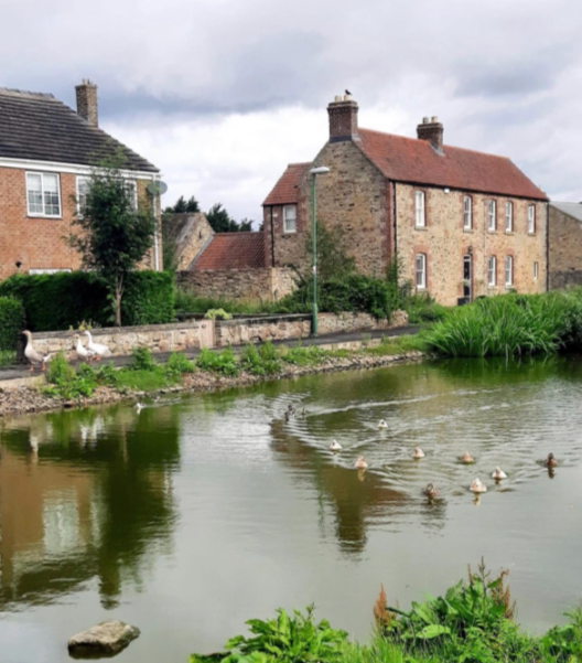
Hett is one of County Durham’s Green Villages, it’s probably the largest of such. We are a small community of about 250 persons, living in 90+ homes built around a central Green, complete with pond, ducks and geese. It lies 4- 5 miles South of Durham. It is now part of the Parish of Croxdale and Hett though it used to be its own parish with a small church. Hett days is mainly a commuter settlement though its origins lie in farming, when agriculture required manual labour and the housing stock was either farms or cottages for agricultural workers.
As mechanisation gathered pace in the 20th century and the higher wages of the industrial North East lured people away some dereliction set in by 1930. After the 2nd World War, Durham County Council needed to evaluate its housing stock, much of it old, run down and primitive especially in previously prosperous mining areas where collieries had been worked out or ceased during the Depression of the 1920s-30s.
Hett was classified as a Category C village – not suitable for development – and apart from the remaining farms it faced demolition. Fortunately, a developer realised latent potential and the village received a new lease of life through the building of the new houses which now form The Green, South Green [1974] and Grove Court [1972]. Subsequent infill in the 1990s and since 2000 complete the quadrilateral formed by East, West and North Streets together with South Green and Grove Court. There remain two working farms with several others in the surrounding area – with an emphasis on arable or mixed farming.
The nearest town is Spennymoor approximately 3 miles away. Spennymoor has a range of shops including ASDA, Aldi and Lidl supermarkets, local shops and a Post Office. It also contains the nearest schools- nursery, primary and secondary.
Durham is the nearest “city” and has a historic Castle, Cathedral, Town Hall and other buildings. The Cathedral was completed in 1094 and is the largest Romanesque building in Europe. The Castle, is now a hall of residence for Durham’s prestigious university.
Newcastle upon Tyne is the nearest large city, with all the services, shops and entertainments.
Roads out of Hett are:
- Hett Lane – “the principal road” going S to the new roundabout on the A167 at the Coach and Horses [gritted in winter] or NW to Sunderland Bridge passing the Cemetery and becoming rather winding [now gritted in winter].
- Leemans Lane exiting E between Grove Court and East Street – a single track route leading to Falls Farm, Hett Moor and the A688 for the A1M [not gritted in winter].
- Access to the A1M north is best via the A688 either via Leemans Lane or the Thinford roundabout – N to Newcastle, Berwick and Edinburgh.
- Access to the A1M south is best via the A167 past Newton Aycliffe until Jct.59.
- The A688 gives access to E. Durham and the coast or W to Bishop Auckland, Barnard Castle, and the A66 over the Pennines to Penrith or Tebay and the M6.
- Hett is fortunate in having easy access to the Durham Coastline – now a remarkable stretch of varied cliffed or sandy beaches with protected wildlife and plant areas. This stretches N from Seaton Carew near Hartlepool via Castle Eden, Blackhall Rocks, Seaham to Seaburn, Marsden and South Shields.
- Equally easy access is via Bishop Auckland, Staindrop and Eggleston to Upper Teesdale – Middleton, Langdon Beck and Cow Green or via Tow Law, Wolsingham and Stanhope to Upper Weardale. Both are rural Areas of Outstanding Natural Beauty [AONBs], scenically stunning and steeped in the history of lead mining.
- The R.Tees rises on the slopes of Cross Fell [highest of the Pennines] whilst the R.Wear rises only 2 kms away and the R.South Tyne rises only 200 metres away from the Tees yet they exit to the N.Sea at Middlesbrough, Sunderland and Tynemouth respectively.
- The Yorkshire Dales National Park lies to the S of the cross-Pennine A66 trunk road and the Northumberland National Park is no great distance beyond Newcastle.
The nearest bus routes are:
A] Arriva service7/7A on the A167 – path across the fields from West End- to Darlington or Durham or from the Coach & Horses.
B] Arriva service 6 to Spennymoor and Bishop Auckland or beyond + Durham in reverse from Croxdale.
C] Northern service X21 to Newcastle via Durham or to Bishop Auckland on return, calls at Croxdale.
Rail services:
Durham Station is on the East Coast Mainline with fast electric trains to Newcastle [12 mins.], Edinburgh [1.45 hrs], Glasgow, [2.40], York [50 mins], Peterborough [2 hrs] London [2.40/3 hrs].
Hett Land Plans – historical plans of the village
There are now 2 historical plans of the village available to view by clicking on the links at the foot of this page
Please be patient waiting for the documents to open.
1] Hett Land Plan 1770 MW
This plan shows land ownership around the village going back to 1770
The original document [in pieces!] is the personal property of Margaret Wilson of Mount Huley Farm. Margaret has kindly made this source material available to Hett Village Hall Association [HVHA]
2] Hett Land Plan 1897 LG
This plan is a facsimile for which we are obliged to Les Griffiths. Les explains that he came across this plan in the course of renovation work at 4 West Street in the village in 2012 and he has kindly made this material available to HVHA.